
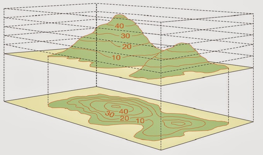
We offer comprehensive contour survey services to accurately map and represent the topography of a land area. Contour surveys provide valuable information about the elevation, slopes, and relief of the terrain, which is essential for various purposes such as land development, engineering design, and environmental assessment.
Throughout the contour survey process, we prioritize accuracy, attention to detail, and client satisfaction. We work closely with our clients to understand their specific requirements and deliver contour survey results that meet their needs. Our team combines technical expertise, advanced surveying technology, and adherence to industry standards to ensure the highest quality contour survey services
Our experienced surveyors utilize advanced surveying equipment, including total stations, GPS receivers, or LiDAR technology, to collect precise elevation data across the survey area. This involves taking measurements at regular intervals to create a grid of elevation points that capture the undulations and contours of the land.
Using the collected elevation data, we generate contour lines that connect points of equal elevation. These contour lines form the basis of a contour map, which provides a visual representation of the land's shape and slopes. Contour lines allow for a better understanding of the land's topography and can aid in designing drainage systems, optimizing construction plans, and assessing site suitability.
We analyze the contour data to determine the slopes and gradients of the land. This information is crucial for identifying areas with steep slopes, which may require special engineering considerations or land use restrictions. Slope analysis also helps in assessing erosion potential, planning road alignments, and implementing appropriate land management practices.
Contour surveys allow us to calculate the volume of earthwork required for grading or leveling the land. By comparing contour lines at different elevations, we can determine the amount of soil that needs to be cut or filled to achieve the desired land surface. Cut and fill calculations are vital for planning excavation, embankment construction, and balancing earthwork quantities.
The contour survey data serves as a foundation for various design and development activities. Architects, engineers, and urban planners rely on contour maps to create accurate site plans, assess the feasibility of construction projects, and optimize the placement of buildings, roads, utilities, and other infrastructure elements.

Get answers and advice from people you want it from.